By PAULA TRACY, InDepthNH.org
CONCORD – State emergency management officials are advising the public to plan for three days of a potential flood emergency beginning late Thursday night particularly in four western counties which are under flood watch: Coos, Grafton, Sullivan and Cheshire.
Of particular concern in terms of property damage are for those with water frontage.
On Lake Sunapee, where the National Weather Service reported Thursday water is 16 inches above normal, the big concern is shoreline damage.
Lake Winnipesaukee, by comparison, is about 4 inches above normal. In many cases, lake levels cannot be drawn down until downstream rivers have crest.
Vanessa Palange, spokesman for the state office of Emergency Management issued a press release to all residents and visitors of the state to be prepared for more flooding potential over the next three days and caution to not drive through moving water that is more than a foot deep.
She said while the immediate focus is on the four counties under the flood watch, the impacts from Sunday’s predicted storms could be statewide and significant.
To be prepared, the department advises all to get a plastic container that can be tightly enclosed, and to put into it non-perishable food, a can opener, flashlights, a first aid kit, food for pets, medicine, cash, copies of important documents, a whistle, change of clothes and a NOAA radio. Also keep handy enough bottled water per person for three days.
There is a website which will tell you what roads are closed. Here is the link https://newengland511.org/
Gov. Chris Sununu, who flew to Cheshire County earlier in the week to observe damage caused by heavy rains Monday, urged folks from here and visiting to “plan ahead, be prepared, monitor local weather forecasts and be on the alert for changing conditions.”
Robert Buxton, head of the state’s emergency response put out a particular warning to those camping along rivers and streams to be particularly aware of their surroundings and to seek higher ground if needed.
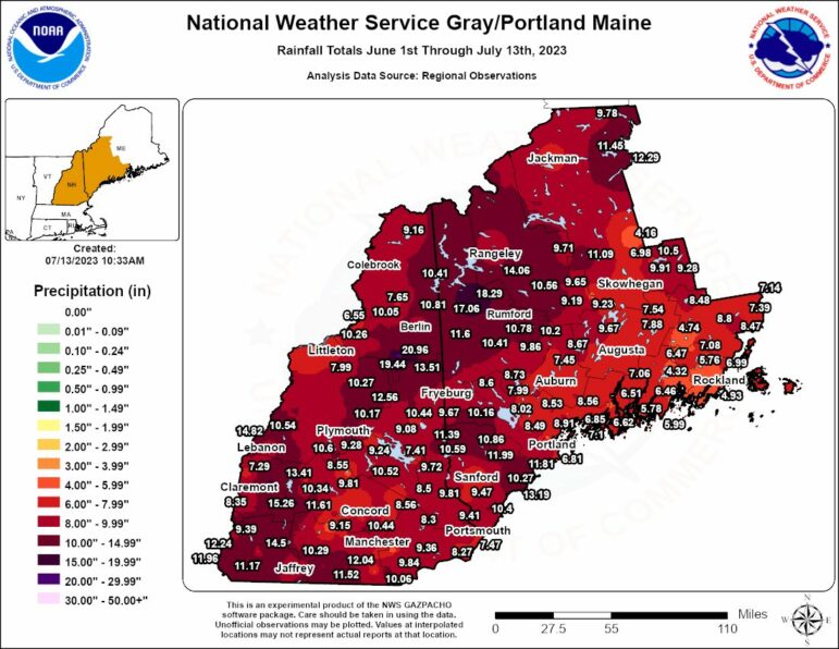
The Southwest corner of the state was hardest hit by the torrential downpours earlier this week, and it appears they are in the crosshairs again, said National Weather Service officials in Gray, Maine.
They provide a map here https://www.facebook.com/photo.php?fbid=651488430341604&set=a.225869419570176&type=3&ref=embed_page which shows how much rain has already fallen, saturating the ground and in many cases, more than 15 inches have been recorded since June 1.
Sarah Thunberg, meteorologist for the National Weather Service in Gray, Maine, said people should expect an unsettled pattern to continue starting Friday and particularly noticeable on Sunday and into Monday.
“We haven’t got a break” from the rain she said, and while the NWS goes eight days out in terms of its forecasts, some forecast models indicate the pattern persists through the month of July.
She explained that there is a very big low pressure mass high in the atmosphere over Eastern Canada that is just sitting there, allowing for this persistent rain and it looks like New England is in the path for moisture coming from the south to just stall.
On Sunday, a predicted cold front will bump up against it making the rain more widespread.
In the summer, she noted, with heat and humidity during the day contributes to a lot of pop up showers that are adding to the amount of rain.
Concerns for lakefront erosion are popping up across the state due to high water.
It has at least one organization calling on folks to navigate their boats at headway speed, if at all and contact Commissioner of Safety Robert Quinn to urge that there be no-wake limits until the water levels recede.
The state dam bureau is working to release as much water from lakes as possible, but it is having a hard time keeping up.
Lake Sunapee Protective Association, citing the high water levels there, have urged boaters to move at only headway speed for now.
“Water levels continue to rise throughout our watershed. Weeks of heavy rain are continuing to impact roads, beaches and docks in our watershed. If you are boating, please use caution to avoid hazards floating in the water. Reduce your speed and don’t create wakes that will damage inundated docks and erode shorelines.
The DES dam bureau is letting water out of the Sunapee Dam at a consistently high rate, but the amount of rain and the need to protect homes and businesses downstream means that lake levels will remain high in the coming weeks,” an online update at LSPA reads.
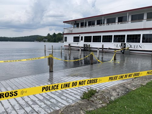
The Sunapee Harbor public docks and Newbury docks are closed but the Sunapee Harbor Boat Launch is open and Sunapee Harbor Cruises are running their cruises with caution, it reads.
The Sunapee State Park/Beach Boat Launch is open.
“LSPA is advocating for no-wake orders from the state, and our local representatives are working hard to make that happen. NH Marine Patrol and our town police do not have the authority to change boating speed limits or to issue no-wake orders for the lakes in our watershed, so the orders would have to come from the state level.”
If you would like to express your concerns and advocate for change in public policy related to these issues, you can contact NH Department of Safety Commissioner Robert Quinn at 603-271-2791 or through email at robert.quinn@dos.nh.gov. You can express your concerns about safety and about environmental impacts including shoreline erosion and flooding septic systems.
DOCK CONCERNS
If you have a seasonal dock with removable decking, consider removing the deck boards to keep them from floating away.
If your boat is on a lift, make sure it is above the high water level so that the waves cannot move it up and down on the lift and if your lift has a hydraulic powerpack, make sure it doesn’t get swamped on the dock, the organization advises.
If a dock is permanent, keep an eye on the frame to make sure it is not separating from the support below it.
Consider re-tying your boat everyday as high water can cause tie lines to tighten so much that they may break.
SEPTIC SYSTEMS
Weeks of heavy rains have saturated soils and are causing some septic systems to fail. If you suspect that your septic system isn’t functioning properly, please contact your septic company for an evaluation.
Stormwater runoff carries sediment and pollutants into lakes and streams and can cause cyanobacteria blooms and other water quality problems. To get free advice about how to address these issues, consider participating in the state’s Watershed Wise program. Your landscaping choices can have a big impact.
LSPA’s Watershed Wise Program helps property owners to identify changes that can be made, such as additional plantings near the water’s edge, to improve the water quality of streams, lakes and ponds within the Lake Sunapee WatershedThere were no reports of deaths or injuries related to the recent rains, but a campground was evacuated Sunday night in advance of the Monday rains, impacting about 150 people staying at Pilgrim Pines Camp on Swanzey Lake.
Swanzey Lake Dam was also damaged but not breached, said Corey Clark, chief engineer for the state’s Dam Bureau at NH Department of Environmental Services.
Clark said while assessments are underway across the state, the Forest Lake Dam in Winchester is the only one he knows of that was completely breached.
It was considered in poor condition by the state but had a low hazard rating, meaning few if any homes or people were likely to be swept away downstream.