Public Information Statement
Spotter Reports
National Weather Service Gray ME
455 PM EST Sun Jan 20 2019

The following are unoffical observations taken during the past 6
hours for the storm that has been affecting our region. Appreciation
is extended to highway departments...cooperative observers...Skywarn
spotters and media for these reports. This summary is also available
on our home page at weather.gov/gray

********************STORM TOTAL SNOWFALL********************

LOCATION          STORM TOTAL     TIME/DATE   COMMENTS
                     SNOWFALL           OF
                     /INCHES/   MEASUREMENT

MAINE

...Androscoggin County...
   Mechanic Falls         8.0  1139 AM  1/20  Trained Spotter
   Durham                 6.8   409 PM  1/20  NWS Employee

...Cumberland County...
   3 N North Windham      8.5   339 PM  1/20  NWS Employee
   Gray                   8.0   246 PM  1/20  NWS Employee
   Scarborough            7.0   338 PM  1/20  Social Media
   Brunswick              6.5   115 PM  1/20  Social Media
   Gray NWS Office        6.1   341 PM  1/20  NWS Office
   Cumberland Center      6.0   329 PM  1/20  NWS Employee
   3 ESE Standish         5.5   440 PM  1/20  Trained Spotter
   Portland Jetport       5.3   341 PM  1/20  ASOS

...Franklin County...
   Carrabassett Valley   14.0   125 PM  1/20  Public
   3 W Chesterville      10.0   159 PM  1/20  Trained Spotter
   1 NNE New Vineyard     9.0   246 PM  1/20  Trained Spotter

...Kennebec County...
   Winslow               10.8   452 PM  1/20  Social Media
   Hallowell              9.0   338 PM  1/20  Social Media
   Readfield              9.0  1111 AM  1/20  Social Media
   Augusta                7.0  1152 AM  1/20  Amateur Radio

...Knox County...
   1 E South Thomaston   11.0   329 PM  1/20  Trained Spotter
   Hope                  10.0   412 PM  1/20  Trained Spotter
   1 SSW Camden           8.2  1152 AM  1/20  Trained Spotter

...Lincoln County...
   Pemaquid              10.5   332 PM  1/20  Amateur Radio
   Bristol               10.0  1104 AM  1/20  Amateur Radio
   Wiscasset              8.5   331 PM  1/20  Amateur Radio
   Jefferson              8.0  1105 AM  1/20  Amateur Radio
   1 SSE Alna             8.0   405 PM  1/20  Trained Spotter
   Waldoboro              8.0  1105 AM  1/20  Amateur Radio
   Nobleboro              8.0  1106 AM  1/20  Amateur Radio
   Boothbay               7.0  1106 AM  1/20  Amateur Radio

...Oxford County...
   Newry                 16.0   126 PM  1/20  Public
   Bryant Pond           13.0   121 PM  1/20  Social Media
   Paris                 12.0  1151 AM  1/20  Amateur Radio
   2 NE Oxford           12.0   301 PM  1/20  Trained Spotter
   Bethel                12.0  1148 AM  1/20  Social Media
   1 W Otisfield          8.0  1059 AM  1/20  changed to sleet
   4 WSW Turner           7.5   224 PM  1/20  sleet and snow

...Sagadahoc County...
   Bath                   8.4  1149 AM  1/20  Social Media

...Somerset County...
   5 ESE Norridgewock    10.0  1155 AM  1/20  Trained Spotter

...Waldo County...
   Thorndike             18.0   314 PM  1/20  Amateur Radio
   3 ENE Searsmont       12.0  1200 PM  1/20  Trained Spotter
   Burnham                8.0  1154 AM  1/20  Amateur Radio
   2 N Knox               7.3  1107 AM  1/20  Trained Spotter
   2 NNW Belfast          7.0  1107 AM  1/20  Trained Spotter

...York County...
   3 SW West Newfield    10.0   437 PM  1/20  Trained Spotter
   1 ENE Springvale       8.3  1140 AM  1/20  Trained Spotter
   York                   7.8   347 PM  1/20  Social Media
   Biddeford              6.0   146 PM  1/20  Social Media
   Hollis                 5.4  1206 PM  1/20  INCLUDES 0.9" SLEET
   2 NNW Saco             5.2   243 PM  1/20  Social Media
   1 NNE Saco             5.2   308 PM  1/20  Social Media

NEW HAMPSHIRE

...Belknap County...
   1 SW Ahern State Par   6.3  1108 AM  1/20  Trained Spotter

...Carroll County...
   Sandwich              12.0   106 PM  1/20  1.39 liquid
   Bartlett              12.0   341 PM  1/20  Social Media
   1 N Madison            9.5   247 PM  1/20  Trained Spotter
   2 W North Conway       8.0  1203 PM  1/20  HALES LOCATION
   Wolfeboro              6.5   328 PM  1/20  Amateur Radio

...Cheshire County...
   1 E Spofford          11.0   247 PM  1/20  Trained Spotter
   Winchester             6.5  1246 PM  1/20  Amateur Radio

...Coos County...
   1 SE Lancaster         8.8  1138 AM  1/20  Trained Spotter
   Whitefield             6.0   316 PM  1/20  Amateur Radio

...Grafton County...
   Lincoln               10.0   126 PM  1/20  Loon Mtn
   Franconia              9.0   128 PM  1/20  Public

...Hillsborough County...
   Weare                  6.2  1140 AM  1/20  changed to sleet
   Hudson                 6.0   337 PM  1/20  Social Media
   Nashua                 5.9   115 PM  1/20  SN/PL combined
   Manchester ASOS        5.6   450 PM  1/20  ASOS
   Goffstown              5.5   309 PM  1/20  Social Media

...Merrimack County...
   Concord ASOS           4.5   342 PM  1/20  ASOS

...Rockingham County...
   4 NNW Derry            7.9   120 PM  1/20  Trained Spotter
   Greenland              5.6   319 PM  1/20  Co-Op Observer
   Raymond                5.0   318 PM  1/20  Amateur Radio

...Strafford County...
   Milton                10.0   122 PM  1/20  Social Media
   2 SSE Strafford        4.7   433 PM  1/20  Trained Spotter

...Sullivan County...
   Washington             8.0   121 PM  1/20  Social Media
URGENT – WINTER WEATHER MESSAGE
National Weather Service Gray ME
351 AM EST Sun Jan 20 2019
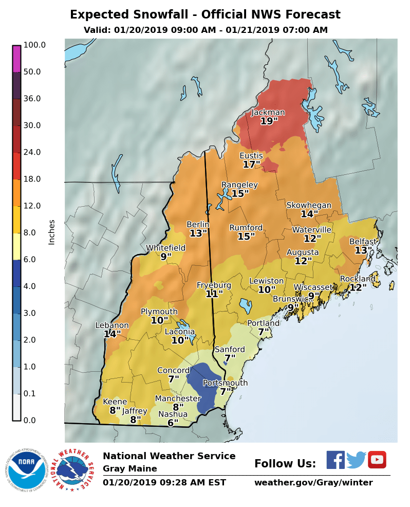
…MAJOR WINTER STORM CONTINUES…
.A low pressure moving into the Mid Atlantic continues to spread
snow across the region this morning. This system will track along
the southern New England coastline and into the Gulf of Maine
today. Snow has increased quickly in intensity this morning, and
will be heavy at times through mid morning. Widespread double
digits snowfall totals are still expected, with some sleet and
freezing rain mixing in after sunrise for southern New Hampshire
and coastal western Maine. While mixed precipitation is expected
to remain mostly sleet, ice accumulation up to one quarter inch is
possible. Driving conditions will be treacherous through Sunday
afternoon.
Arctic air will pour in behind the departing system late today
into Monday. Significant blowing and drifting is possible through
Monday, even after the snow has stopped falling. In addition,
strong northwest winds approaching 30 mph gusts will combine with
the bitterly cold air to produce dangerous wind chills starting
tonight.
NHZ003>005-007-011-015-201700-
/O.NEW.KGYX.WC.Y.0003.190121T0500Z-190121T2100Z/
/O.CON.KGYX.WS.W.0002.000000T0000Z-190121T0600Z/
Northern Grafton-Northern Carroll-Southern Grafton-Sullivan-
Cheshire-Western And Central Hillsborough-
Including the cities of Bethlehem, Lincoln, Littleton,
Sugar Hill, Thornton, Waterville Valley, Woodstock, Jackson,
North Conway, Albany, Conway, Chatham, Crawford Notch, Lebanon,
Lyme, Ashland, Ellsworth, Holderness, Plymouth, Rumney,
Claremont, Cornish, Unity, Croydon, Goshen, Grantham, Lempster,
Newport, Charlestown, Gilsum, Keene, Marlow, Sullivan, Surry,
Jaffrey, Amherst, Milford, Mont Vernon, Goffstown, Peterborough,
Sharon, Hollis, and Weare
351 AM EST Sun Jan 20 2019
…WINTER STORM WARNING REMAINS IN EFFECT UNTIL 1 AM EST MONDAY…
…WIND CHILL ADVISORY IN EFFECT FROM MIDNIGHT TONIGHT TO 4 PM
EST MONDAY…
* WHAT…Heavy snow and mixed precipitation. Very cold wind chills
expected. Additional snow accumulations of 6 to 10 inches and
ice accumulations of around one tenth of an inch for southern
New Hampshire. Wind chills as low as 25 below zero expected.
* WHERE…Portions of central, northern and southern New
Hampshire.
* WHEN…For the Winter Storm Warning, until 1 AM EST Monday.
For the Wind Chill Advisory, from midnight tonight to 4 PM EST
Monday.
* ADDITIONAL DETAILS…Travel will be very difficult to dangerous,
with low visibility in snow and blowing snow, and slippery
roads. The dangerously cold wind chills could cause frostbite
on exposed skin in as little as 10 minutes.
PRECAUTIONARY/PREPAREDNESS ACTIONS…
A Winter Storm Warning means significant amounts of snow, sleet
and ice will make travel very hazardous or impossible.
A Wind Chill Advisory means that cold air and the wind will
combine to create low wind chills. Frostbite and hypothermia can
occur if precautions are not taken. Make sure you wear a hat and
gloves.
For a more precise forecast for your specific location…go to
www.weather.gov/gray.